Services
August 6, 2012
Strategic alliances and association with two well respected Satellite scanning companies, has changed the capabilities and increased positive target confirmations to 97%. As of present we have conducted over 149 Satellite scans between the two entities we contracted with. Out of the 149 scans, we have had a positive confirmation of 27 targets of parent materials and 11 targets of deformed/ micron or alluvial AU. The satellite has located 2 confirmed oil and gas deposits for their customers and 3 confirmed ship wreck sites. The rest of the scans have proven to be either removed or non-existent.
We are experiencing a 97% success rate on targets that were confirmed with the satellite. The satellite can identify a variety of targets including but not limited to: oil and gas, ore deposits, buried treasure, ship wrecks, tunnels, voids, caves, water, precious and industrial gems and a host of other types of desired targets from the surface to a depth of more than 19,000 ft below the ground and in water.
This type of scanning coupled with ground based Electromagnetic Surveys, Ground penetrating Radar, Proton Magnetometer, Forward Looking Infra-Red, Quantum Electro Dynamics, Magneto Tellurics, side Scan Sonar and more have helped to identify, quantify and pin point a variety of targets for our customers.
Geo Scan Inc. does not own the satellite, but rather leases time for use directly. Geo Scan Inc. does own all of its own ground based scanning equipment, which we use to accurately assess a target, confirmed by the satellite scan and perform scans of known deposits.
Inherently Satellite scanning is bit more costly and carries some percentage points on confirmed targets that are removed and monetized, but the cost savings for the project over the term of the project is significantly reduced. Customers who have extracted or who are in the process of extracting targets are experiencing very large cost savings from their original budgets. Target areas are a minimum of 1.5 km for the smaller entity and 40/ 2400 acres for the larger company, there is no maximum. There are very few limitations to the area's that can be scanned. Scans can be taken in most every country and water body in the world. Military zones are off limits and certain other countries in the world may be off limits as well.
Depending on which company we use, the customer can either receive verbal directions only and/or a full report of the satellite's findings in 30-45 days, with verbal communication of findings at the time of the scan.
The cost can vary depending on the services desired.
Ground based follow up scanning if desired or necessary will be separate and billed according to the customer's needs. The satellite can triangulate a cell or sat phone on site or can base its findings solely on GPS. The customer will enter into a contract agreement prior to any scanning activities.
Geo Scan Inc. and the Satellite Companies have full non-disclosure and confidentiality agreements to protect customer sites and data.
The satellites use a combination of different types of equipment to produce the results; this includes, but, is not limited to: Infra-red spectroscopy, lidar, gamma ray, nuclear magnetic resonance and approximately 17 other highly advanced technologies to pinpoint target size, depths and make up.
I hope this covers the basics of the services we can offer you, or call me direct and I will be happy to answer any questions or concerns.
Sincerely,
John Casey
First Stage: Satellite
Geo Scan Inc. will set up a comprehensive Satellite scan of your given detection area. The customer receives accurate location, size and type of deposit. The customer may also receive a full report of the satellite findings.
Second Stage: Ground based acquisition and mapping
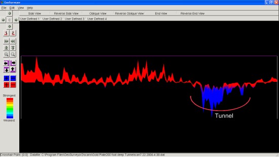
Geo Scan will come to your property and do a series of scans and or drilling. If any anomaly or void or tunnel is located, the ground position will be marked, extensive testing will be performed and the data will be authenticated by our professional geologist to determine its value.
Geo Scan is a sub-surface scanning company with a non -evasive approach to underground scanning. Geo Scan will provide you all of the information necessary to put your project into motion.
These are some of the ground based services we offer.
- Our Geo Physical Electromagnetic Surveyor is one of the most technologically advanced pieces of equipment available on the market today. 2d-3d color mapping, It has the capability to show ground data in real time as it is scanned, to approx 280 feet or deeper depending on conditions. The deepest recorded measurements were over 370ft.
- Our Ground Penetrating Radar Unit has the capability to pick up most ground anomalies and sub surface disturbances up to approximately 150 feet or deeper depending on ground conditions and antenna used.
- Proton Magnetometer, for specific field measurements of ferrous objects over land and water.
- Structure Scan, for reading the integrity of concrete structures, including but not limited to:re-bar placement, Spalding, rusting, penetration location, wire chases and pipe location.
- FLIR thermal sensing camera, locate hot and cold spots in building envelops, map vent locations and flow rates for mine shafts. Check bearings on ore carts and mechanicals while in motion.
- Nuclear Magnetic Resonance , Magneto Tellurics, locating and mapping of oil and gas deposits at depths greater than 20,000'
- Side scan sonar, underwater mapping
- Long range detecting and mass quantification.
Call now for an estimate for your project.
Oil and Gas Exploration
EM complements reflection seismic and reduces risk.
Oil and gas exploration companies have used the reflection seismic technique for years and rely on its strengths while recognizing its limitations. Factors in the geologic structure of the prospective area can form a high-velocity barrier, degrading resolution below the barrier and limiting the depth of investigation. Volcanic rocks near the surface or in the section, dense, highly-indurate limestone, and crystalline basement thrust over sediments are common obstacles to definitive modeling with seismic. In addition, rugged terrain, jungle vegetation, and geographic remoteness can make seismic difficult, costly, or even impossible to use.
Many oil companies world-wide have used electromagnetic (EM) methods as a cost-effective, useful complement to seismic techniques and as a substitute where seismic cannot be used at all. Both natural-source methods (MT) and man-made, controlled-source methods (IP and CSEM) have made valuable contributions in refining geologic models, reducing exploration risk, and improving production monitoring.
Base and Precious Metals Exploration
As the search for new ore deposits moves ever deeper, both major and junior mining companies are increasingly using MT, EM and AMT for both brown fields and Greenfields exploration. INCO's 1991 proof-of-concept study in Sudbury, Ontario started this trend with two AMT sites that sensed a 1750 meter-deep nickel deposit. Falconbridge followed with a feasibility study in 1996 that accurately located two Ni-Cu mineralized zones at ~800 m and ~1350 m.

Since then, Falconbridge has acquired over 2000 MT/AMT sites in the Sudbury basin and elsewhere. In 1999, INCO acquired ~1500 MT/AMT sites at the Voisey's Bay nickel deposit discovered in 1996. Today, thousands of EM / EMT / AMT sites are measured every year by worldwide companies, demonstrating the value that industry players place on these techniques.
Tomorrow's mineral discoveries will likely come from depths greater than known ore bodies and may be covered by thick layers of overburden. Finding these deposits requires more sophisticated technology than traditional prospecting methods. Geo Scan Inc answers that need. EM/ MT/AMT is a proven supplement or alternative to expensive traditional approaches like Diamond Drilling and borehole geophysics and less-costly but shallow-penetrating airborne EM techniques.