Satellite Scanning
Magnetic Resonance Frequency Spectrometry as a New Method of Mineral Prospecting
Method's Concept
This method is based on processing the reflected atomic matter received from the surface of the earth of various natural, minerals signals at the surface or at depth, into a result that we can then interpret into meaningful data. Because each deposit material has a specific atomic frequency resonance this method is very specific to each element being sought.
Method's Process
Created by Scientists, this new method of utilizing magnetic resonance as an effective geophysical method of mineral exploration and prospecting has passed numerous practical tests since 1998. The results of these tests and subsequent investigation of the land and of the sea shelf have been highly successful. The method has changed, back in the beginning photographic plates were subjected to radioactive isotopes to highlight the areas of mineral resonance, now a days, digital data is taken directly from the satellite and much faster algorithms process the data 1 element at a time. No nuclear or radioisotopes are necessary
This method of geo-holographic mineral exploration was developed based on utilizing up-to-date achievements of science and technology. This technology allows remote exploration and prospecting of all kinds of minerals whether on the land or on the sea shelf. This gives the advantage of fully assessing the availability and value of the industrial development of the potential deposit. Nasa using the crism satellite mapped the mineral substrates of mars successfully.
In a short amount of time, this unique geophysical method of mineral exploration and prospecting provides for an immediate return on investment. It is because of the physical principles and innovative technologies that this method is centered around (this method does not require the traditional invasive steps of locating deposits) and therefore your savings will be large.
This method of mineral exploration and prospecting is carried out in 2 multifaceted stages:
- Search Stage: this includes procurement of satellite data of the area under investigation in different spectra. These images are then processed with scientific geo-holographic equipment. After careful review by our engineers the results are the preliminary search results, filtering is applied and are then used in conjunction with the 2nd stage. Accurate base information is achieved in the first stages
- Prospecting Stage: using the geo-holographic results from the first stage, our engineers work directly on-site with additional equipment to more specifically locate where deposit boundaries lie, the depths of the deposit occurrence, the quality of and deposit thickness will be specified and the optimal spots for exploratory digging and/ or producing wells. The final reports are given to the client for the specific area under investigation
Method's Capabilities
- Area of Investigation is unlimited (any region, land, or sea shelf around the Earth);
- Minimum Area of Investigation is 1/2sq. Mi (320 acres);
- Maximum Area of Investigation is unlimited;
- Sounding Depth – Average 500 ft up to 20,000 ft
- Detectable Minerals - water, oil, natural gas, different minerals in ore beddings;
- Sensitiveness – 1-1.5 grams of substance per ton of the ore body;
- Detection Success of Deposits – on Stage 1 - greater than 80%, on Stage 2 - 97 % (for water and hydrocarbons, for all other minerals – not less than 95%);
- Work Execution Terms are usually 1-2 Calendar Months for 1st stage of Investigation and 2-6 Months for the 2nd stage. Depending on total square miles of Investigation and scope of work;
- Method Safety - this method is environmentally sensible and completely safe.
Scientific Preconditions
It is well known in the physics of the atomic nucleus the data about magnetic and electrical moments are of special importance. According to the works of the academician E.Zavadsky (1946), all nuclei with spins that are not equal to zero have the magnetic moment μ1, which is connected with the spin of this nucleus J, nuclear magneto – μnucl and proportional to gyro magnetic relation – g1: μ1 = g1 x J x μnucl;
The gyro magnetic relation g1 is a constant magnitude and is equal to ratio of nuclear magnetic moment to the nuclear angular moment. If we bring the atomic nucleus with spin J and moment μ1 to the magnetic field with intensity ?, then we can see magnetic interaction, and the energy of interaction of magnetic moment of the nucleus with the field Wm will be proportional to H: Wm = μ1 x H x (m/J);
where m is the projection of the vector J to the direction of intensity of the magnetic field. I.e., the energy of interaction is proportional to the intensity of the magnetic field.
According to the quantum mechanics, several energetic (quantum) levels of nucleus energy are possible, and the difference of values of 2 adjacent energetic levels will be equal to:
ΔWm = g1 x ?nucl x H;
Then the frequency corresponding to this energy will be called Larmor's frequency:
fL = ΔWm / h;
where h is Planck's constant. If we place the sample body to the constant orienting magnetic field I (the spins will be oriented along the magnetic field) and simultaneously apply variable rotating magnetic field Ivar, but perpendicular to the orienting nucleus of the field — ?, then at the frequency of the variable field equal to Larmor's frequency fL, we can observe resonant absorption and resonance scattering of the energy by the sample body.
Thus, having recorded resonance frequencies for each substance in nuclear magnetic resonance facility and then influence the examined substance by the generator with such a frequency, then by presence of resonance phenomena it is possible to judge about presence of the searched body in the depths of the earth. Only in case when the modulated signal of the generator hits the searched substance, a perturbation action to the receiving device of the vector magnetic field of this substance occurs.
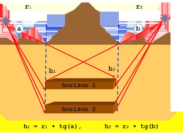
As a rule, the value of Larmor's frequencies for different substances present in the magnetic field of the Earth, lies within terahertz range (100 GHz - 100 THz). The visualization of a deposit's boundaries is carried out during special processing of space photographs in radiation fields and their introduction into rotary magnetic field (Kirlian effect). Then, with the help of impact of a narrow resonance signal on mineral deposits directly from the Earth's surface it is possible to detect direction on an underground object with the sough for substance, and by slope angle it is possible to calculate the depth of an object underground. Such sounding of a locality region with the help of test resonance radiation allows to link the deposit's boundaries on an invisible surface of earth to the map of the region, define qualitative and quantitative characteristics of mineral deposits, and choose points for industrial boring for effective development of reserves.
Additional links:
- Stanford University. Nuclear Magnetic Resonance
- Appl, Magn. Reson. 5,399-406 (1993). Modulation Effects in Non-Drilling NMR in the Earth's Field. D.V. Trushkin, O.A. Shushakov and A.V. Legchenko
- China University of Petroleum. Mobile NMR for geophysical analysis and materials testing
- And many others…