News
Gold Prices Drive Increased Business.
With the addition of new Allies for Satellite based phase 1 Scanning, Geo Scan Inc. is poised to wipe out the competition. 2012 is shaping up to be the best ever, the rate of target confirmations has tripled from 2011. This is the start of a new beginning for us and our customers.
With the rising prices of gold and precious metals, Geo Scan Inc. finds its self in an excellent position to help mine and claim owners maximize their potential. The cost of scanning for these resources, due to the technology advances has a very distinct advantage for the company and the mine owners.
Geo Scan Inc. has positioned its self to be one of the leaders in sub-surface scanning of precious mineral deposits. Over the course of the next few years the company will be seeking maximize their earning potential. Acquisitions of up-graded software, new scan technologies and the ability to accurately asses data, will undoubtedly bring us to the top.
Public and Private investment firms are showing interest in the services we offer. Interested investors are urged to contact the owners for a prospectus of expansion of operations.
June 23, 2012
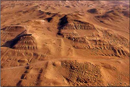
Archaeologists Solve Mystery of Palmyra Using Advanced Satellite Imagery
Archaeologists Solve Mystery of Palmyra A Norwegian-Syrian team of archaeologists has solved one of the great puzzles of the Roman Empire: why was the vibrant city of Palmyra located in the middle of the Syrian Desert?
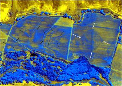
An avenue in ancient Palmyra, Syria (Zeledi) In Roman times, Palmyra was the most important point along the trade route linking the east and west, reaching a population of 100,000 inhabitants. But its history has always been shrouded in mystery: what was a city that size doing in the middle of the desert? How could so many people live in such an inhospitable place nearly 2,000 years ago? Norwegian researchers collaborated with colleagues from Syria for four years to find answers. “These findings provide a wealth of new insight into Palmyra’s history,” said Jørgen Christian Meyer, a professor at the University of Bergen and manager of the project funded by the Research Council of Norway. The Norwegian archaeologists approached the problem from a novel angle – instead of examining the city itself, they studied an enormous expanse of land just to the north. Along with their Syrian colleagues from the Palmyra Museum and aided by satellite scans and photos, they catalogued a large number of ancient remains visible on the Earth’s surface. Advanced Nuclear Magnetic Resonance was used to enhance underground structures, "In this way, we were able to form a more complete picture of what occurred within the larger area."
June 2012
A new remote sensing technology has peeled away layers of mud and rock near Peru’s Cahuachi desert to reveal an ancient adobe pyramid, Italian researchers announced on Friday at a satellite imagery conference in Rome…
Nicola Masini and Rosa Lasaponara of Italy’s National Research Council (CNR) discovered the pyramid by analyzing images from the satellite Quickbird, which they used to penetrate the Peruvian soil.
The researchers investigated a test area along the river Nazca. Covered by plants and grass, it was about a mile away from Cahuachi’s archaeological site, which contains the remains of what is believed to be the world’s biggest mud city.
Via Quickbird, Masini and colleagues colleced high-resolution infrared and multispectral images. After the researchers optimized the data with special algorithms, the result was a detailed visualization of a pyramid extending over a 97,000-square-foot (9,000-square-meter) area.